
ACEF is developing a range of data services including data portals and visualisation capabilities.
We are using open source solutions such as:
(please note that these are still in development)
We are also collaborating with the Australian Ocean Data Network to use and enhance their data portal.
Coastal Data Portal
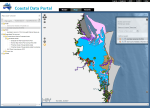
The Coastal Data Portal allows users to search and browse coastal datasets from a range of sources.
ACEF is collating key coastal data such as water quality, coastal habitats, marine turtles and beach morphology. These will continue to be added to the data portal.
Data from the portal will be linked up to the TERN Data Discovery Portal and the Australian Ocean Data Network.
National Marine Turtle Database
The National Marine Turtle Database is being developed to house data from state custodians and to make this data more accessible for a wide variety of uses.
The database is being developed using the Atlas of Living Australia's Biological Data Recording System. The same system is being used to house seagrass datasets which are being collated as part of an ACEAS funded workshop - Australian Seagrass Habitats.
CoastalCOMS beach monitoring and video data
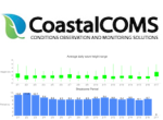
CoastalCOMS provides video content analytics and environmental monitoring solutions around Australia. Through a collaboration with ACEF, video recordings, shoreline analysis data and wave data are being made available to researchers free of charge.
For more information, visit our Coastal Data Portal and view the CoastalCOMS data layers. Data can be downloaded directly (after registration) by following the links to the CoastalCOMS data portal.
Coastal Satellite Imagery
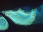
In collaboration with Geoscience Australia, CSIRO has also acquired WorldView 2 imagery for a a range of coastal locations around Australia. This data can be made available to project partners. If you are interested in collaborating with us on this data, please get in touch.
For a list of available satellite imagery, Click here